


les ARAVIS Chalet du curé.2022.07.02

trusgnachjf
User
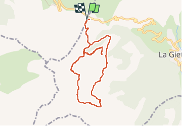

Length
10.8 km

Max alt
1816 m

Uphill gradient
428 m
Km-Effort
16.5 km

Min alt
1483 m

Downhill gradient
428 m
Boucle
Yes
Creation date :
2022-07-02 08:18:16.645
Updated on :
2022-07-02 16:02:45.491
5h54
Difficulty : Very easy

FREE GPS app for hiking
 SityTrail
IGN / Geographical institutes
SityTrail Plus
The world is yours!
About
Trail Walking of 10.8 km to be discovered at Auvergne-Rhône-Alpes, Upper Savoy, La Clusaz. This trail is proposed by trusgnachjf.
Positioning
Country:
France
Region :
Auvergne-Rhône-Alpes
Department/Province :
Upper Savoy
Municipality :
La Clusaz
Location:
Unknown
Start:(Dec)
Start:(UTM)
303203 ; 5082923 (32T) N.
Comments