


Entre les vignes

didierc13
User

Length
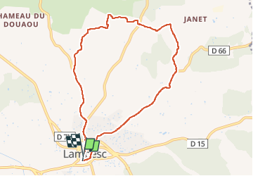
8.7 km

Max alt
323 m

Uphill gradient
133 m
Km-Effort
10.5 km

Min alt
201 m

Downhill gradient
132 m
Boucle
Yes
Creation date :
2022-07-03 04:20:12.0
Updated on :
2022-07-03 06:03:28.195
1h42
Difficulty : Medium

FREE GPS app for hiking
 SityTrail
IGN / Geographical institutes
SityTrail Plus
The world is yours!
About
Trail Walking of 8.7 km to be discovered at Provence-Alpes-Côte d'Azur, Bouches-du-Rhône, Lambesc. This trail is proposed by didierc13.
Description
A faire de préférence le matin de bonne heure pour profiter des chants d’oiseaux
Positioning
Country:
France
Region :
Provence-Alpes-Côte d'Azur
Department/Province :
Bouches-du-Rhône
Municipality :
Lambesc
Location:
Unknown
Start:(Dec)
Start:(UTM)
682378 ; 4835817 (31T) N.
Comments