


16 km +600-1150 rando pas de l'oeil .col vert depart benne villard retour glovettes

Charignon
User
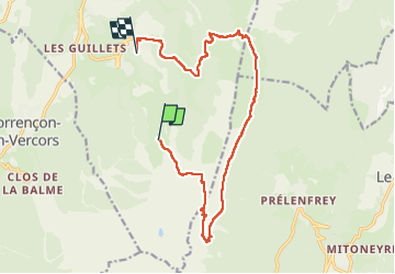

Length
15.7 km

Max alt
1959 m

Uphill gradient
602 m
Km-Effort
25 km

Min alt
1205 m

Downhill gradient
1114 m
Boucle
No
Creation date :
2022-07-03 07:39:25.266
Updated on :
2022-07-03 15:39:01.515
7h56
Difficulty : Difficult

FREE GPS app for hiking
 SityTrail
IGN / Geographical institutes
SityTrail Plus
The world is yours!
About
Trail Walking of 15.7 km to be discovered at Auvergne-Rhône-Alpes, Isère, Villard-de-Lans. This trail is proposed by Charignon.
Positioning
Country:
France
Region :
Auvergne-Rhône-Alpes
Department/Province :
Isère
Municipality :
Villard-de-Lans
Location:
Unknown
Start:(Dec)
Start:(UTM)
702425 ; 4989471 (31T) N.
Comments