


TOUR DE ST JACUES

surceneux
User
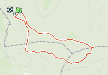

Length
4.9 km

Max alt
1093 m

Uphill gradient
108 m
Km-Effort
6.4 km

Min alt
1005 m

Downhill gradient
110 m
Boucle
Yes
Creation date :
2022-07-03 14:06:46.109
Updated on :
2022-07-03 16:22:31.948
1h15
Difficulty : Very easy

FREE GPS app for hiking
 SityTrail
IGN / Geographical institutes
SityTrail Plus
The world is yours!
About
Trail Walking of 4.9 km to be discovered at Grand Est, Vosges, Xonrupt-Longemer. This trail is proposed by surceneux.
Description
TOUR DE ST JACQUES DE GERARDMER
Positioning
Country:
France
Region :
Grand Est
Department/Province :
Vosges
Municipality :
Xonrupt-Longemer
Location:
Unknown
Start:(Dec)
Start:(UTM)
344569 ; 5325452 (32U) N.
Comments