


4 ou 5 sucs

psesjs
User
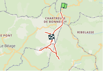

Length
12.3 km

Max alt
1592 m

Uphill gradient
544 m
Km-Effort
19.2 km

Min alt
1382 m

Downhill gradient
446 m
Boucle
No
Creation date :
2022-07-03 07:15:04.666
Updated on :
2022-07-03 19:27:47.357
3h47
Difficulty : Difficult

FREE GPS app for hiking
 SityTrail
IGN / Geographical institutes
SityTrail Plus
The world is yours!
About
Trail Walking of 12.3 km to be discovered at Auvergne-Rhône-Alpes, Ardèche, Borée. This trail is proposed by psesjs.
Positioning
Country:
France
Region :
Auvergne-Rhône-Alpes
Department/Province :
Ardèche
Municipality :
Borée
Location:
Unknown
Start:(Dec)
Start:(UTM)
593506 ; 4970098 (31T) N.
Comments