


Ardeche mezilhac

yann07
User
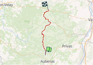

Length
69 km

Max alt
1121 m

Uphill gradient
1885 m
Km-Effort
91 km

Min alt
263 m

Downhill gradient
1091 m
Boucle
No
Creation date :
2022-07-03 20:01:30.615
Updated on :
2022-07-03 20:14:30.106
15h50
Difficulty : Very difficult

FREE GPS app for hiking
 SityTrail
IGN / Geographical institutes
SityTrail Plus
The world is yours!
About
Trail Walking of 69 km to be discovered at Auvergne-Rhône-Alpes, Ardèche, Vals-les-Bains. This trail is proposed by yann07.
Positioning
Country:
France
Region :
Auvergne-Rhône-Alpes
Department/Province :
Ardèche
Municipality :
Vals-les-Bains
Location:
Unknown
Start:(Dec)
Start:(UTM)
608271 ; 4946969 (31T) N.
Comments