


Y0 - 2

bob2023
User
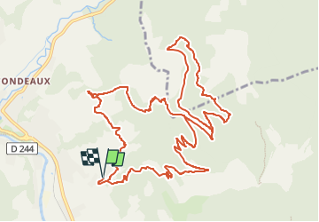

Length
15.9 km

Max alt
990 m

Uphill gradient
890 m
Km-Effort
28 km

Min alt
447 m

Downhill gradient
891 m
Boucle
Yes
Creation date :
2022-07-04 10:05:55.014
Updated on :
2022-07-04 10:22:49.1
3h59
Difficulty : Difficult

FREE GPS app for hiking
 SityTrail
IGN / Geographical institutes
SityTrail Plus
The world is yours!
About
Trail Walking of 15.9 km to be discovered at Auvergne-Rhône-Alpes, Drôme, Die. This trail is proposed by bob2023.
Positioning
Country:
France
Region :
Auvergne-Rhône-Alpes
Department/Province :
Drôme
Municipality :
Die
Location:
Unknown
Start:(Dec)
Start:(UTM)
689556 ; 4957184 (31T) N.
Comments