


sentier de Pėguère (Rioumajou)

ego
User
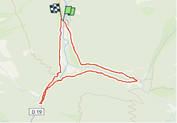

Length
4.9 km

Max alt
1518 m

Uphill gradient
165 m
Km-Effort
7.1 km

Min alt
1381 m

Downhill gradient
166 m
Boucle
Yes
Creation date :
2022-07-04 10:42:54.962
Updated on :
2022-07-04 13:23:26.112
1h31
Difficulty : Medium

FREE GPS app for hiking
 SityTrail
IGN / Geographical institutes
SityTrail Plus
The world is yours!
About
Trail Walking of 4.9 km to be discovered at Occitania, Hautespyrenees, Saint-Lary-Soulan. This trail is proposed by ego .
Positioning
Country:
France
Region :
Occitania
Department/Province :
Hautespyrenees
Municipality :
Saint-Lary-Soulan
Location:
Unknown
Start:(Dec)
Start:(UTM)
279662 ; 4735484 (31T) N.
Comments