


Léry-Forêt de Bord

JMCMoreau
User
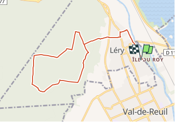

Length
9.6 km

Max alt
130 m

Uphill gradient
169 m
Km-Effort
11.9 km

Min alt
6 m

Downhill gradient
169 m
Boucle
Yes
Creation date :
2022-07-05 04:22:04.883
Updated on :
2022-07-05 04:22:59.434
3h00
Difficulty : Easy

FREE GPS app for hiking
 SityTrail
IGN / Geographical institutes
SityTrail Plus
The world is yours!
About
Trail Walking of 9.6 km to be discovered at Normandy, Eure, Léry. This trail is proposed by JMCMoreau.
Positioning
Country:
France
Region :
Normandy
Department/Province :
Eure
Municipality :
Léry
Location:
Unknown
Start:(Dec)
Start:(UTM)
369927 ; 5460508 (31U) N.
Comments