


Chateauvieux les fossés

i20
User
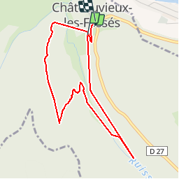

Length
4.3 km

Max alt
586 m

Uphill gradient
279 m
Km-Effort
8 km

Min alt
373 m

Downhill gradient
254 m
Boucle
Yes
Creation date :
2014-12-10 00:00:00.0
Updated on :
2014-12-10 00:00:00.0
3h16
Difficulty : Easy

FREE GPS app for hiking
 SityTrail
IGN / Geographical institutes
SityTrail Plus
The world is yours!
About
Trail Walking of 4.3 km to be discovered at Bourgogne-Franche-Comté, Doubs, Châteauvieux-les-Fossés. This trail is proposed by i20.
Positioning
Country:
France
Region :
Bourgogne-Franche-Comté
Department/Province :
Doubs
Municipality :
Châteauvieux-les-Fossés
Location:
Unknown
Start:(Dec)
Start:(UTM)
287498 ; 5215911 (32T) N.
Comments