


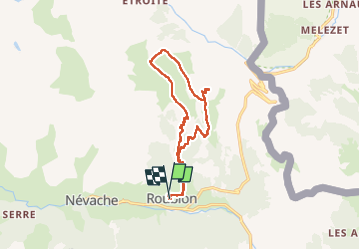
pointe rouge vallée de la Clarée

laurentnecca
User

Length
15.1 km

Max alt
2514 m

Uphill gradient
996 m
Km-Effort
28 km

Min alt
1606 m

Downhill gradient
1003 m
Boucle
Yes
Creation date :
2022-07-05 06:51:53.675
Updated on :
2022-07-05 13:59:22.538
7h06
Difficulty : Difficult

FREE GPS app for hiking
 SityTrail
IGN / Geographical institutes
SityTrail Plus
The world is yours!
About
Trail Walking of 15.1 km to be discovered at Provence-Alpes-Côte d'Azur, Hautes-Alpes, Névache. This trail is proposed by laurentnecca.
Positioning
Country:
France
Region :
Provence-Alpes-Côte d'Azur
Department/Province :
Hautes-Alpes
Municipality :
Névache
Location:
Unknown
Start:(Dec)
Start:(UTM)
313330 ; 4987915 (32T) N.
Comments