Trail Walking Etxalar - Rando Ibanteli - Photo

Rando Ibanteli

 Fab-Oz
Fab-Oz

User

© OpenStreetMap contributors
Length
Length
7.7 km
Max alt
Max alt
681 m
Uphill gradient
Uphill gradient
487 m
Km-Effort
Km-Effort  
14.2 km
Min alt
Min alt
220 m
Downhill gradient
Downhill gradient
489 m
Boucle
Boucle
Yes
Creation date :
2022-07-05 14:00:42.898
Updated on :
2022-07-05 16:57:39.284

(0 Reviews)

Walking
Walking
2h55
Difficulty : Difficult

Scan this QR Code to open this trail in the SityTrail application

FREE GPS app for hiking

Logo SityTrail SityTrail

IGN / Geographical institutes

Download SityTrail from the App Store Download SityTrail from Google Play

Logo SityTrail SityTrail Plus

The world is yours!

Download SityTrail from the App Store Download SityTrail from Google Play Download SityTrail on Huawei AppGallery

About

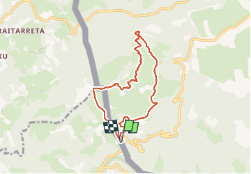
Trail Walking of 7.7 km to be discovered at Navarre, Unknown, Etxalar. This trail is proposed by Fab-Oz.

Description

Au départ du col de Lizzareta
montée jusqu'au sommet d'Ibanteli

ATTENTION ne pas suivre ma trace pour le retour car hors sentier, avec descente à travers les fougères, ronces, et même franchissement de 2 barbelés lol pour retrouver un chemin. normal

Elevation profile

Positioning

Country:
Spain
Region :
Navarre
Department/Province :
Unknown
Municipality :
Etxalar
Location:
Unknown
Start:(UTM)
612065 ; 4790718 (30T) N.


Close
My subscriptions