


BOSLIMPRE

surceneux
User
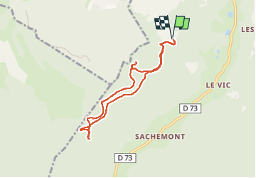

Length
7.1 km

Max alt
889 m

Uphill gradient
276 m
Km-Effort
10.7 km

Min alt
687 m

Downhill gradient
276 m
Boucle
Yes
Creation date :
2022-07-08 13:34:09.3
Updated on :
2022-07-08 18:18:37.17
2h00
Difficulty : Easy

FREE GPS app for hiking
 SityTrail
IGN / Geographical institutes
SityTrail Plus
The world is yours!
About
Trail Walking of 7.1 km to be discovered at Grand Est, Vosges, Ban-sur-Meurthe-Clefcy. This trail is proposed by surceneux.
Description
CIRCUIT AUTOUR DE BOSLIMPRE (TRIANGLE VERT) PRE AGATHE LA MAXERELLE...
Positioning
Country:
France
Region :
Grand Est
Department/Province :
Vosges
Municipality :
Ban-sur-Meurthe-Clefcy
Location:
Unknown
Start:(Dec)
Start:(UTM)
349068 ; 5335459 (32U) N.
Comments