


Ham

andremusin
User
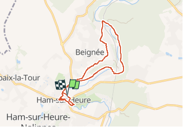

Length
7.5 km

Max alt
187 m

Uphill gradient
123 m
Km-Effort
9.1 km

Min alt
129 m

Downhill gradient
123 m
Boucle
Yes
Creation date :
2022-07-09 12:30:22.807
Updated on :
2022-07-11 07:06:14.318
1h44
Difficulty : Very easy

FREE GPS app for hiking
 SityTrail
IGN / Geographical institutes
SityTrail Plus
The world is yours!
About
Trail Trail of 7.5 km to be discovered at Wallonia, Hainaut, Ham-sur-Heure-Nalinnes. This trail is proposed by andremusin.
Positioning
Country:
Belgium
Region :
Wallonia
Department/Province :
Hainaut
Municipality :
Ham-sur-Heure-Nalinnes
Location:
Unknown
Start:(Dec)
Start:(UTM)
598969 ; 5575452 (31U) N.
Comments