


Givry marche Valérie

XavierFaidix
User

Length
13.4 km

Max alt
438 m

Uphill gradient
426 m
Km-Effort
19.1 km

Min alt
223 m

Downhill gradient
427 m
Boucle
Yes
Creation date :
2022-07-11 08:47:48.071
Updated on :
2022-07-11 14:18:58.128
4h00
Difficulty : Medium

FREE GPS app for hiking
 SityTrail
IGN / Geographical institutes
SityTrail Plus
The world is yours!
About
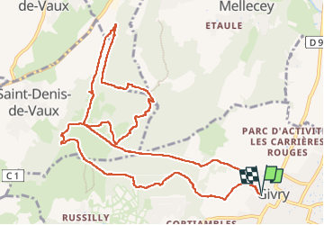
Trail Walking of 13.4 km to be discovered at Bourgogne-Franche-Comté, Saône-et-Loire, Givry. This trail is proposed by XavierFaidix.
Positioning
Country:
France
Region :
Bourgogne-Franche-Comté
Department/Province :
Saône-et-Loire
Municipality :
Givry
Location:
Unknown
Start:(Dec)
Start:(UTM)
632900 ; 5182516 (31T) N.
Comments