


les Rousses. le bief de la chaille

PatriceCocuaud
User
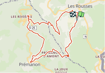

Length
12.6 km

Max alt
1139 m

Uphill gradient
406 m
Km-Effort
18 km

Min alt
899 m

Downhill gradient
404 m
Boucle
Yes
Creation date :
2022-07-11 10:05:16.703
Updated on :
2022-07-11 18:59:46.611
4h49
Difficulty : Medium

FREE GPS app for hiking
 SityTrail
IGN / Geographical institutes
SityTrail Plus
The world is yours!
About
Trail Walking of 12.6 km to be discovered at Bourgogne-Franche-Comté, Jura, Les Rousses. This trail is proposed by PatriceCocuaud.
Positioning
Country:
France
Region :
Bourgogne-Franche-Comté
Department/Province :
Jura
Municipality :
Les Rousses
Location:
Unknown
Start:(Dec)
Start:(UTM)
274226 ; 5151521 (32T) N.
Comments