


SISTERON Sur la route du temps o l s

RobinMicheline
User GUIDE
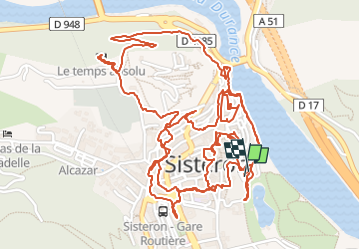

Length
6 km

Max alt
554 m

Uphill gradient
155 m
Km-Effort
8 km

Min alt
462 m

Downhill gradient
152 m
Boucle
Yes
Creation date :
2022-07-12 05:16:50.336
Updated on :
2022-07-12 17:26:04.516
1h36
Difficulty : Medium

FREE GPS app for hiking
 SityTrail
IGN / Geographical institutes
SityTrail Plus
The world is yours!
About
Trail Walking of 6 km to be discovered at Provence-Alpes-Côte d'Azur, Alpes-de-Haute-Provence, Sisteron. This trail is proposed by RobinMicheline.
Photos


24 photos in total. Please click on a photo to see them all in the gallery.
Positioning
Country:
France
Region :
Provence-Alpes-Côte d'Azur
Department/Province :
Alpes-de-Haute-Provence
Municipality :
Sisteron
Location:
Unknown
Start:(Dec)
Start:(UTM)
735417 ; 4897860 (31T) N.
Comments