


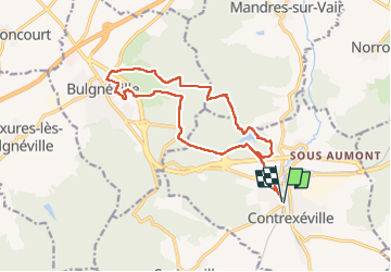
Ccontrex-Bulgnéville-Contrex

parastat
User


3h49
Difficulty : Very difficult

FREE GPS app for hiking
 SityTrail
IGN / Geographical institutes
SityTrail Plus
The world is yours!
About
Trail Walking of 15.2 km to be discovered at Grand Est, Vosges, Contrexéville. This trail is proposed by parastat.
Description
Beaucoup de parties en sous bois: bien par temps chaud.
Il s'agit de la rando n°2: circuit court des deux lacs.
Je la propose dans le sens horaire (donc "à l'envers") par rapport au topo, avec un départ de Contrexéville et quelques variantes.
A ma grande honte, je n'ai pas trouvé la Fontaine des 4 seigneurs, malgré mes recherches.
Pas de difficulté particulière sinon qu'il n'y a pas de fléchage dans ce sens ( que des croix).
A Bulgnéville, l'arborétum est remarquable et mérite une petite visite.
Photos


Positioning
Comments