


Lac du distroit

orsel
User GUIDE
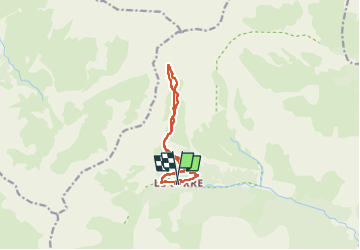

Length
10.5 km

Max alt
2526 m

Uphill gradient
869 m
Km-Effort
22 km

Min alt
1651 m

Downhill gradient
879 m
Boucle
Yes
Creation date :
2022-07-11 08:01:32.112
Updated on :
2022-07-12 14:44:01.174
8h00
Difficulty : Medium

FREE GPS app for hiking
 SityTrail
IGN / Geographical institutes
SityTrail Plus
The world is yours!
About
Trail Walking of 10.5 km to be discovered at Provence-Alpes-Côte d'Azur, Hautes-Alpes, Châteauroux-les-Alpes. This trail is proposed by orsel.
Positioning
Country:
France
Region :
Provence-Alpes-Côte d'Azur
Department/Province :
Hautes-Alpes
Municipality :
Châteauroux-les-Alpes
Location:
Unknown
Start:(Dec)
Start:(UTM)
297064 ; 4946786 (32T) N.
Comments