Trail Walking Azay-le-Rideau - Azay-le-Rideau - Goupillières Baulay - 15.1km 185m 3h35 - 2022 07 12 - Photo

Azay-le-Rideau - Goupillières Baulay - 15.1km 185m 3h35 - 2022 07 12

 Orcal37
Orcal37

User

© OpenStreetMap contributors
Length
Length
15.1 km
Max alt
Max alt
105 m
Uphill gradient
Uphill gradient
187 m
Km-Effort
Km-Effort  
17.6 km
Min alt
Min alt
56 m
Downhill gradient
Downhill gradient
185 m
Boucle
Boucle
Yes
Creation date :
2022-07-12 12:12:19.789
Updated on :
2022-07-12 18:04:09.351

(0 Reviews)

Walking
Walking
3h35
Difficulty : Easy

Scan this QR Code to open this trail in the SityTrail application

FREE GPS app for hiking

Logo SityTrail SityTrail

IGN / Geographical institutes

Download SityTrail from the App Store Download SityTrail from Google Play

Logo SityTrail SityTrail World

The world is yours!

Download SityTrail from the App Store Download SityTrail from Google Play Download SityTrail on Huawei AppGallery

About

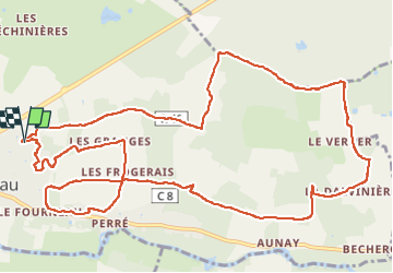
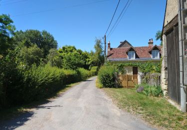
Trail Walking of 15.1 km to be discovered at Centre-Loire Valley, Indre-et-Loire, Azay-le-Rideau. This trail is proposed by Orcal37.

Description

Azay-le-Rideau - Goupillières Baulay - 15.1km 185m 3h35 - 2022 07 12

Elevation profile

Photos

Positioning

Country:
France
Region :
Centre-Loire Valley
Department/Province :
Indre-et-Loire
Municipality :
Azay-le-Rideau
Location:
Unknown
Start:(UTM)
309108 ; 5237817 (31T) N.

Trails nearby

Trail Walking Lignières-de-Touraine - Lignière de Touraine-Le 26-09-2013- Distance 10,4 km - Auteur tintin37 - Photo
Walking
Martinjeanclaude

Walking

Medium
(2)
Lignières-de-Touraine, Centre-Loire Valley, Indre-et-Loire, France
10.4 km | 11.8 km-effort
2h 30min
Yes
Trail Cycle Cheillé - Au Pays d'Azay-le-Rideau - Photo
Cycle
leeho

Cycle

Easy
(1)
Cheillé, Centre-Loire Valley, Indre-et-Loire, France
53 km | 58 km-effort
2h 40min
No
Trail Walking Azay-le-Rideau - Azay-le-Rideau - l'Islette - 17km 220m 4h05 (20mn) - 2021 06 12 - Photo
Walking
Orcal37

Walking

Easy
Azay-le-Rideau, Centre-Loire Valley, Indre-et-Loire, France
17 km | 20 km-effort
4h 5min
Yes
Trail Walking  - Druye - Sentier du menhir - 14km 95m 2h50 - 2019 08 03 - Photo
Walking
Orcal37

Walking

Very easy
, Centre-Loire Valley, Indre-et-Loire, France
14 km | 15.2 km-effort
2h 50min
Yes
Trail Walking Villaines-les-Rochers - Villaines-les-Rochers - 16.4km 260m 4h00 - 2018 07 22 - public - Photo
Walking
Orcal37

Walking

Easy
Villaines-les-Rochers, Centre-Loire Valley, Indre-et-Loire, France
16.4 km | 19.9 km-effort
4h 5min
Yes
Trail Walking Lignières-de-Touraine - Lignières-de-Touraine - la Chapelle-aux-Naux - 24 km 4h45mn  - Photo
Walking
Orcal37

Walking

Medium
Lignières-de-Touraine, Centre-Loire Valley, Indre-et-Loire, France
24 km | 27 km-effort
4h 45min
Yes
Trail Walking Azay-le-Rideau - Azay le Rideau (les vergers) - Photo
Walking
LEMENIO

Walking

Easy
Azay-le-Rideau, Centre-Loire Valley, Indre-et-Loire, France
11.3 km | 13.2 km-effort
3h 3min
No
Trail Walking Cheillé - Azay le Rideau 2012-04-15 - Photo
Walking
sdargaud

Walking

Very easy
(1)
Cheillé, Centre-Loire Valley, Indre-et-Loire, France
9.9 km | 11.7 km-effort
2h 33min
No
Trail Walking Cheillé - La-Chapelle-St-Blaise (Azay) - GR3 nord - 18.3km 180m 3h55 - 2018 04 15 - Photo
Walking
Orcal37

Walking

Medium
Cheillé, Centre-Loire Valley, Indre-et-Loire, France
18.3 km | 21 km-effort
3h 55min
Yes


Close
My subscriptions