


Tour du Val d'Azun Jour 1

piem
User
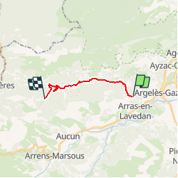

Length
11.1 km

Max alt
1275 m

Uphill gradient
440 m
Km-Effort
16 km

Min alt
922 m

Downhill gradient
159 m
Boucle
No
Creation date :
2015-03-09 00:00:00.0
Updated on :
2015-03-09 00:00:00.0
3h37
Difficulty : Easy

FREE GPS app for hiking
 SityTrail
IGN / Geographical institutes
SityTrail Plus
The world is yours!
About
Trail Walking of 11.1 km to be discovered at Occitania, Hautespyrenees, Arras-en-Lavedan. This trail is proposed by piem.
Description
Tour du Val d'Azur en 6 jours avec des enfants à partir de 7 ans. Nuit au refuge du Haugarou.


Positioning
Country:
France
Region :
Occitania
Department/Province :
Hautespyrenees
Municipality :
Arras-en-Lavedan
Location:
Unknown
Start:(Dec)
Start:(UTM)
733976 ; 4765029 (30T) N.
Comments