


c23

parastat
User

Length
9.2 km

Max alt
401 m

Uphill gradient
152 m
Km-Effort
11.2 km

Min alt
327 m

Downhill gradient
160 m
Boucle
Yes
Creation date :
2022-07-13 06:34:36.344
Updated on :
2022-07-13 15:11:09.858
2h07
Difficulty : Medium

FREE GPS app for hiking
 SityTrail
IGN / Geographical institutes
SityTrail Plus
The world is yours!
About
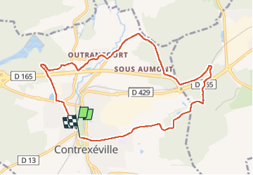
Trail Walking of 9.2 km to be discovered at Grand Est, Vosges, Contrexéville. This trail is proposed by parastat.
Description
Partie est de la randonnée n° 23.
Alternance de pistes (beaucoup) au soleil et de sentiers (peu) ombragés.
Pas de difficultés.
Positioning
Country:
France
Region :
Grand Est
Department/Province :
Vosges
Municipality :
Contrexéville
Location:
Unknown
Start:(Dec)
Start:(UTM)
714968 ; 5340779 (31U) N.
Comments