


Murat et tourbières fait

pidjam
User
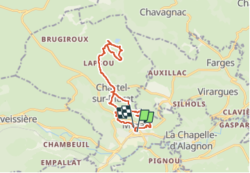

Length
14.6 km

Max alt
1240 m

Uphill gradient
460 m
Km-Effort
21 km

Min alt
919 m

Downhill gradient
432 m
Boucle
Yes
Creation date :
2022-07-13 06:40:29.24
Updated on :
2022-07-13 11:23:39.603
4h42
Difficulty : Medium

FREE GPS app for hiking
 SityTrail
IGN / Geographical institutes
SityTrail Plus
The world is yours!
About
Trail Walking of 14.6 km to be discovered at Auvergne-Rhône-Alpes, Cantal, Murat. This trail is proposed by pidjam.
Positioning
Country:
France
Region :
Auvergne-Rhône-Alpes
Department/Province :
Cantal
Municipality :
Murat
Location:
Murat
Start:(Dec)
Start:(UTM)
489708 ; 4995283 (31T) N.
Comments