


Mandeure....,.Montandon

tiene
User
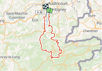

Length
59 km

Max alt
834 m

Uphill gradient
1681 m
Km-Effort
81 km

Min alt
332 m

Downhill gradient
1688 m
Boucle
No
Creation date :
2022-07-13 11:37:13.282
Updated on :
2022-07-13 16:53:24.831
4h15
Difficulty : Very difficult

FREE GPS app for hiking
 SityTrail
IGN / Geographical institutes
SityTrail Plus
The world is yours!
About
Trail Mountain bike of 59 km to be discovered at Bourgogne-Franche-Comté, Doubs, Mathay. This trail is proposed by tiene.
Positioning
Country:
France
Region :
Bourgogne-Franche-Comté
Department/Province :
Doubs
Municipality :
Mathay
Location:
Unknown
Start:(Dec)
Start:(UTM)
332806 ; 5256180 (32T) N.
Comments