


Pont de Terenez 13-07-2022

jmrobin
User
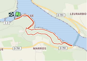

Length
4.7 km

Max alt
75 m

Uphill gradient
98 m
Km-Effort
6 km

Min alt
11 m

Downhill gradient
99 m
Boucle
Yes
Creation date :
2022-07-13 12:59:29.017
Updated on :
2022-07-13 17:08:58.415
1h26
Difficulty : Medium

FREE GPS app for hiking
 SityTrail
IGN / Geographical institutes
SityTrail Plus
The world is yours!
About
Trail Walking of 4.7 km to be discovered at Brittany, Finistère, Argol. This trail is proposed by jmrobin.
Photos

Positioning
Country:
France
Region :
Brittany
Department/Province :
Finistère
Municipality :
Argol
Location:
Unknown
Start:(Dec)
Start:(UTM)
404613 ; 5347542 (30U) N.
Comments