


Chateau du Lac Pierre Chatel 264 +

claude nier
User
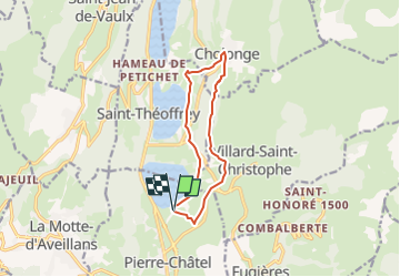

Length
10.6 km

Max alt
1145 m

Uphill gradient
264 m
Km-Effort
14.2 km

Min alt
930 m

Downhill gradient
265 m
Boucle
Yes
Creation date :
2022-07-14 09:34:03.637
Updated on :
2022-07-14 09:27:39.654
3h13
Difficulty : Easy

FREE GPS app for hiking
 SityTrail
IGN / Geographical institutes
SityTrail Plus
The world is yours!
About
Trail Walking of 10.6 km to be discovered at Auvergne-Rhône-Alpes, Isère, Pierre-Châtel. This trail is proposed by claude nier.
Description
Petite rando sympa pour Tout le Monde
Positioning
Country:
France
Region :
Auvergne-Rhône-Alpes
Department/Province :
Isère
Municipality :
Pierre-Châtel
Location:
Unknown
Start:(Dec)
Start:(UTM)
719254 ; 4983134 (31T) N.
Comments