


Monrond - Mont d'Or aller retour

mousetik
User
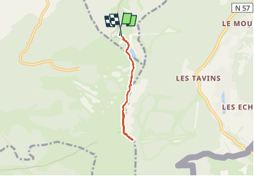

Length
4.6 km

Max alt
1450 m

Uphill gradient
171 m
Km-Effort
6.9 km

Min alt
1337 m

Downhill gradient
179 m
Boucle
Yes
Creation date :
2022-07-14 08:22:20.122
Updated on :
2022-07-14 09:58:40.377
1h35
Difficulty : Medium

FREE GPS app for hiking
 SityTrail
IGN / Geographical institutes
SityTrail Plus
The world is yours!
About
Trail Walking of 4.6 km to be discovered at Bourgogne-Franche-Comté, Doubs, Métabief. This trail is proposed by mousetik.
Description
balade très sympathique avec magnifique vue sur la Suisse et les Alpes Françaises
Positioning
Country:
France
Region :
Bourgogne-Franche-Comté
Department/Province :
Doubs
Municipality :
Métabief
Location:
Unknown
Start:(Dec)
Start:(UTM)
297876 ; 5180886 (32T) N.
Comments