


Beaucroissant-Parmenie

raymondfn
User
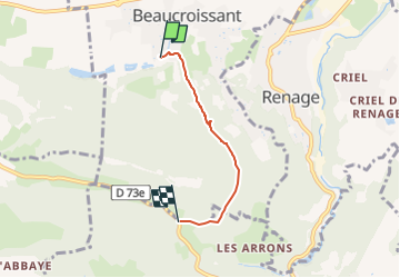

Length
3.1 km

Max alt
605 m

Uphill gradient
177 m
Km-Effort
5 km

Min alt
425 m

Downhill gradient
25 m
Boucle
No
Creation date :
2022-07-14 14:08:39.883
Updated on :
2022-07-14 14:29:17.613
52m
Difficulty : Easy

FREE GPS app for hiking
 SityTrail
IGN / Geographical institutes
SityTrail Plus
The world is yours!
About
Trail Walking of 3.1 km to be discovered at Auvergne-Rhône-Alpes, Isère, Beaucroissant. This trail is proposed by raymondfn.
Positioning
Country:
France
Region :
Auvergne-Rhône-Alpes
Department/Province :
Isère
Municipality :
Beaucroissant
Location:
Unknown
Start:(Dec)
Start:(UTM)
693253 ; 5023256 (31T) N.
Comments