


Moy de l’Aisne

jpblimond
User
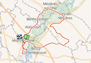

Length
20 km

Max alt
109 m

Uphill gradient
159 m
Km-Effort
22 km

Min alt
54 m

Downhill gradient
158 m
Boucle
Yes
Creation date :
2022-07-14 10:55:29.0
Updated on :
2022-07-14 15:35:36.825
4h39
Difficulty : Medium

FREE GPS app for hiking
 SityTrail
IGN / Geographical institutes
SityTrail Plus
The world is yours!
About
Trail Walking of 20 km to be discovered at Hauts-de-France, Aisne, Moÿ-de-l'Aisne. This trail is proposed by jpblimond.
Positioning
Country:
France
Region :
Hauts-de-France
Department/Province :
Aisne
Municipality :
Moÿ-de-l'Aisne
Location:
Unknown
Start:(Dec)
Start:(UTM)
526180 ; 5511044 (31U) N.
Comments