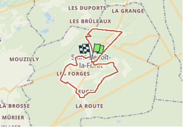
Saint-Benoît-la-Forêt - GR3 PR - 15.1km 205m 3h50 - 2022 07 14

Orcal37
User GUIDE

Length
15.1 km

Max alt
128 m

Uphill gradient
207 m
Km-Effort
17.8 km

Min alt
61 m

Downhill gradient
208 m
Boucle
Yes
Creation date :
2022-07-14 12:13:29.731
Updated on :
2022-07-14 19:01:20.911
3h50
Difficulty : Easy

FREE GPS app for hiking
 SityTrail
IGN / Geographical institutes
SityTrail Plus
The world is yours!
About
Trail Walking of 15.1 km to be discovered at Centre-Loire Valley, Indre-et-Loire, Saint-Benoît-la-Forêt. This trail is proposed by Orcal37.
Description
Saint-Benoît-la-Forêt - GR3 PR sentier découverte - 15.1km 205m 3h50 - 2022 07 14
Photos


Positioning
Country:
France
Region :
Centre-Loire Valley
Department/Province :
Indre-et-Loire
Municipality :
Saint-Benoît-la-Forêt
Location:
Unknown
Start:(Dec)
Start:(UTM)
297284 ; 5233245 (31T) N.
Comments