


Au lus les bains st lizier d Ustou

viaul
User GUIDE
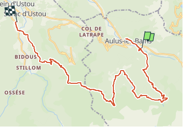

Length
24 km

Max alt
1656 m

Uphill gradient
1441 m
Km-Effort
43 km

Min alt
730 m

Downhill gradient
1491 m
Boucle
No
Creation date :
2022-07-14 17:50:26.0
Updated on :
2022-07-14 17:50:29.281
9h47
Difficulty : Very difficult

FREE GPS app for hiking
 SityTrail
IGN / Geographical institutes
SityTrail Plus
The world is yours!
About
Trail Walking of 24 km to be discovered at Occitania, Ariège, Aulus-les-Bains. This trail is proposed by viaul.
Positioning
Country:
France
Region :
Occitania
Department/Province :
Ariège
Municipality :
Aulus-les-Bains
Location:
Unknown
Start:(Dec)
Start:(UTM)
364937 ; 4738509 (31T) N.
Comments