


Stage4

fpolini
User
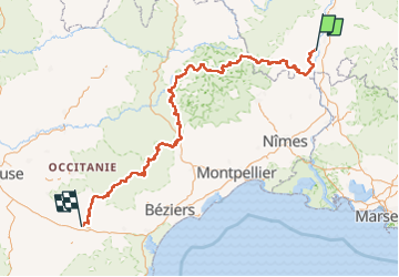

Length
526 km

Max alt
1455 m

Uphill gradient
16529 m
Km-Effort
746 km

Min alt
48 m

Downhill gradient
16527 m
Boucle
No
Creation date :
2022-07-17 13:44:29.299
Updated on :
2022-07-17 13:45:56.286
169h39
Difficulty : Very difficult

FREE GPS app for hiking
 SityTrail
IGN / Geographical institutes
SityTrail Plus
The world is yours!
About
Trail Walking of 526 km to be discovered at Auvergne-Rhône-Alpes, Ardèche, Viviers. This trail is proposed by fpolini.
Description
Converted from a KML file KML2GPX.COM
Positioning
Country:
France
Region :
Auvergne-Rhône-Alpes
Department/Province :
Ardèche
Municipality :
Viviers
Location:
Unknown
Start:(Dec)
Start:(UTM)
632542 ; 4927171 (31T) N.
Comments