


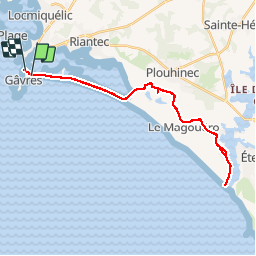
gavres pointe Etel

legereric
User

Length
31 km

Max alt
25 m

Uphill gradient
183 m
Km-Effort
33 km

Min alt
0 m

Downhill gradient
184 m
Boucle
No
Creation date :
2014-12-10 00:00:00.0
Updated on :
2014-12-10 00:00:00.0
2h12
Difficulty : Easy

FREE GPS app for hiking
 SityTrail
IGN / Geographical institutes
SityTrail Plus
The world is yours!
About
Trail Cycle of 31 km to be discovered at Brittany, Morbihan, Gâvres. This trail is proposed by legereric.
Positioning
Country:
France
Region :
Brittany
Department/Province :
Morbihan
Municipality :
Gâvres
Location:
Unknown
Start:(Dec)
Start:(UTM)
473915 ; 5282590 (30T) N.
Comments
bien