


Villemoisson-sur-Orge Cyclisme

Lucquiaud
User
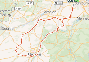

Length
80 km

Max alt
154 m

Uphill gradient
587 m
Km-Effort
88 km

Min alt
58 m

Downhill gradient
587 m
Boucle
Yes
Creation date :
2022-07-17 15:18:08.23
Updated on :
2022-07-17 15:22:15.278
5h18
Difficulty : Very difficult

FREE GPS app for hiking
 SityTrail
IGN / Geographical institutes
SityTrail Plus
The world is yours!
About
Trail Road bike of 80 km to be discovered at Ile-de-France, Essonne, Bondoufle. This trail is proposed by Lucquiaud.
Positioning
Country:
France
Region :
Ile-de-France
Department/Province :
Essonne
Municipality :
Bondoufle
Location:
Unknown
Start:(Dec)
Start:(UTM)
454079 ; 5384708 (31U) N.
Comments