


2022 07-18 Revens Gard

josy31
User
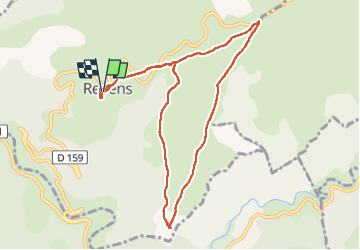

Length
10.4 km

Max alt
861 m

Uphill gradient
167 m
Km-Effort
12.6 km

Min alt
781 m

Downhill gradient
175 m
Boucle
Yes
Creation date :
2022-07-18 05:44:09.145
Updated on :
2022-07-18 10:24:27.634
2h34
Difficulty : Easy

FREE GPS app for hiking
 SityTrail
IGN / Geographical institutes
SityTrail Plus
The world is yours!
About
Trail Walking of 10.4 km to be discovered at Occitania, Gard, Revens. This trail is proposed by josy31.
Description
En grande partie ombragée.
Positioning
Country:
France
Region :
Occitania
Department/Province :
Gard
Municipality :
Revens
Location:
Unknown
Start:(Dec)
Start:(UTM)
523675 ; 4881594 (31T) N.
Comments