


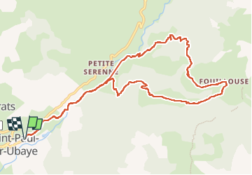
SAINT PAUL . Fouillouse o

RobinMicheline
User GUIDE

Length
12.6 km

Max alt
1949 m

Uphill gradient
596 m
Km-Effort
21 km

Min alt
1452 m

Downhill gradient
595 m
Boucle
Yes
Creation date :
2022-07-18 05:29:20.656
Updated on :
2022-07-24 17:06:09.337
3h52
Difficulty : Easy

FREE GPS app for hiking
 SityTrail
IGN / Geographical institutes
SityTrail Plus
The world is yours!
About
Trail Walking of 12.6 km to be discovered at Provence-Alpes-Côte d'Azur, Alpes-de-Haute-Provence, Saint-Paul-sur-Ubaye. This trail is proposed by RobinMicheline.
Description
Magnifique
Photos


Positioning
Country:
France
Region :
Provence-Alpes-Côte d'Azur
Department/Province :
Alpes-de-Haute-Provence
Municipality :
Saint-Paul-sur-Ubaye
Location:
Unknown
Start:(Dec)
Start:(UTM)
321524 ; 4931638 (32T) N.
Comments