


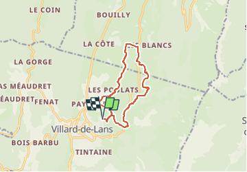
VILLARD DE LANS 11km

jpb83
User

Length
11.1 km

Max alt
1131 m

Uphill gradient
244 m
Km-Effort
14.3 km

Min alt
997 m

Downhill gradient
246 m
Boucle
Yes
Creation date :
2022-07-18 15:11:16.007
Updated on :
2022-07-18 15:11:18.257
1h30
Difficulty : Medium

FREE GPS app for hiking
 SityTrail
IGN / Geographical institutes
SityTrail Plus
The world is yours!
About
Trail Running of 11.1 km to be discovered at Auvergne-Rhône-Alpes, Isère, Villard-de-Lans. This trail is proposed by jpb83.
Positioning
Country:
France
Region :
Auvergne-Rhône-Alpes
Department/Province :
Isère
Municipality :
Villard-de-Lans
Location:
Unknown
Start:(Dec)
Start:(UTM)
701650 ; 4994367 (31T) N.
Comments