


LA GR MOUCHEROLLE, LAC MOUCHEROLLE DÉPART COTE 2000

jpb83
User
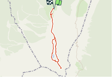

Length
6.8 km

Max alt
2054 m

Uphill gradient
421 m
Km-Effort
12.4 km

Min alt
1749 m

Downhill gradient
424 m
Boucle
Yes
Creation date :
2022-07-19 11:33:52.271
Updated on :
2022-07-19 11:33:54.15
2h48
Difficulty : Easy

FREE GPS app for hiking
 SityTrail
IGN / Geographical institutes
SityTrail Plus
The world is yours!
About
Trail Walking of 6.8 km to be discovered at Auvergne-Rhône-Alpes, Isère, Villard-de-Lans. This trail is proposed by jpb83.
Positioning
Country:
France
Region :
Auvergne-Rhône-Alpes
Department/Province :
Isère
Municipality :
Villard-de-Lans
Location:
Unknown
Start:(Dec)
Start:(UTM)
702549 ; 4989247 (31T) N.
Comments