


têtes des chétives

sdroneau
User
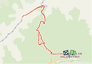

Length
14.5 km

Max alt
2629 m

Uphill gradient
1353 m
Km-Effort
33 km

Min alt
1294 m

Downhill gradient
1353 m
Boucle
Yes
Creation date :
2022-07-19 05:27:04.97
Updated on :
2022-07-19 13:31:47.3
5h33
Difficulty : Very difficult

FREE GPS app for hiking
 SityTrail
IGN / Geographical institutes
SityTrail Plus
The world is yours!
About
Trail Walking of 14.5 km to be discovered at Auvergne-Rhône-Alpes, Isère, Valjouffrey. This trail is proposed by sdroneau.
Positioning
Country:
France
Region :
Auvergne-Rhône-Alpes
Department/Province :
Isère
Municipality :
Valjouffrey
Location:
Unknown
Start:(Dec)
Start:(UTM)
267462 ; 4976899 (32T) N.
Comments