


Enges - Grand Chaumont - Enges

Mangold
User
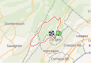

Length
10.8 km

Max alt
1252 m

Uphill gradient
476 m
Km-Effort
17.1 km

Min alt
815 m

Downhill gradient
476 m
Boucle
Yes
Creation date :
2014-12-10 00:00:00.0
Updated on :
2014-12-10 00:00:00.0
--
Difficulty : Unknown

FREE GPS app for hiking
 SityTrail
IGN / Geographical institutes
SityTrail Plus
The world is yours!
About
Trail Other activity of 10.8 km to be discovered at Neuchâtel, Unknown, Enges. This trail is proposed by Mangold.
Positioning
Country:
Switzerland
Region :
Neuchâtel
Department/Province :
Unknown
Municipality :
Enges
Location:
Unknown
Start:(Dec)
Start:(UTM)
349030 ; 5213385 (32T) N.
Comments