


chaud clapier2

verozerr
User
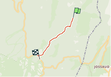

Length
2.9 km

Max alt
1510 m

Uphill gradient
10 m
Km-Effort
3.3 km

Min alt
1409 m

Downhill gradient
102 m
Boucle
No
Creation date :
2022-07-20 12:26:59.782
Updated on :
2022-07-20 21:50:37.136
47m
Difficulty : Easy

FREE GPS app for hiking
 SityTrail
IGN / Geographical institutes
SityTrail Plus
The world is yours!
About
Trail Walking of 2.9 km to be discovered at Auvergne-Rhône-Alpes, Drôme, Bouvante. This trail is proposed by verozerr.
Description
Le 20072022
2 eme partie de Chaud Clapier à Serre Plumé
Positioning
Country:
France
Region :
Auvergne-Rhône-Alpes
Department/Province :
Drôme
Municipality :
Bouvante
Location:
Unknown
Start:(Dec)
Start:(UTM)
685598 ; 4977365 (31T) N.
Comments