


38 - cascade de la fauge

guilmanu
User
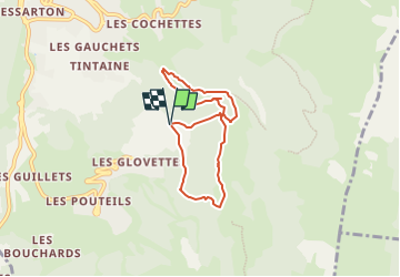

Length
6.4 km

Max alt
1346 m

Uphill gradient
291 m
Km-Effort
10.3 km

Min alt
1124 m

Downhill gradient
284 m
Boucle
Yes
Creation date :
2022-07-23 09:51:00.704
Updated on :
2022-07-23 16:08:56.782
2h27
Difficulty : Very easy

FREE GPS app for hiking
 SityTrail
IGN / Geographical institutes
SityTrail Plus
The world is yours!
About
Trail Walking of 6.4 km to be discovered at Auvergne-Rhône-Alpes, Isère, Villard-de-Lans. This trail is proposed by guilmanu.
Positioning
Country:
France
Region :
Auvergne-Rhône-Alpes
Department/Province :
Isère
Municipality :
Villard-de-Lans
Location:
Unknown
Start:(Dec)
Start:(UTM)
702229 ; 4992376 (31T) N.
Comments