


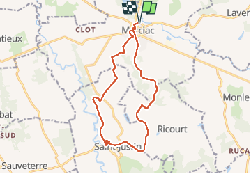
circuit des champs-PR Marciac

parastat
User


4h10
Difficulty : Very difficult

FREE GPS app for hiking
 SityTrail
IGN / Geographical institutes
SityTrail Plus
The world is yours!
About
Trail Walking of 15.9 km to be discovered at Occitania, Gers, Marciac. This trail is proposed by parastat.
Description
Proposée par OT de Marciac.
Départ du parking en face de l'Astrada.
De la route mais quelques passages sympas en sous-bois.
Au niveau de Castex:
-la route vers Bragardou mène à des propriétés privées.
-suivre le balisage PR en laissant la barrière à MAIN GAUCHE ( sinon vous ferez comme moi, le tour du champ pour rien) et vous arriverez au chemin creux qui monte ( un peu raide) vers Justin.
Si vous suivez le GPX fourni pat l'OT de Marciac, à Castex ne pas suivre le balisage PR, mais suivre l' ancienne trace ( comme la mienne).
Positioning
Comments