


SERRE CHEVALIER 12KM

jpb83
User
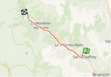

Length
12.8 km

Max alt
1514 m

Uphill gradient
276 m
Km-Effort
15.9 km

Min alt
1320 m

Downhill gradient
86 m
Boucle
No
Creation date :
2022-07-24 18:44:17.878
Updated on :
2022-07-24 18:44:19.823
1h30
Difficulty : Medium

FREE GPS app for hiking
 SityTrail
IGN / Geographical institutes
SityTrail Plus
The world is yours!
About
Trail Running of 12.8 km to be discovered at Provence-Alpes-Côte d'Azur, Hautes-Alpes, Saint-Chaffrey. This trail is proposed by jpb83.
Positioning
Country:
France
Region :
Provence-Alpes-Côte d'Azur
Department/Province :
Hautes-Alpes
Municipality :
Saint-Chaffrey
Location:
Unknown
Start:(Dec)
Start:(UTM)
310701 ; 4977407 (32T) N.
Comments