


étape 6

eeeeee
User

Length
51 km

Max alt
165 m

Uphill gradient
325 m
Km-Effort
55 km

Min alt
99 m

Downhill gradient
265 m
Boucle
No
Creation date :
2022-07-24 07:10:17.991
Updated on :
2022-07-25 08:07:42.367
2h43
Difficulty : Very difficult

FREE GPS app for hiking
 SityTrail
IGN / Geographical institutes
SityTrail Plus
The world is yours!
About
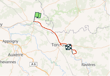
Trail Bicycle tourism of 51 km to be discovered at Bourgogne-Franche-Comté, Yonne, Saint-Florentin. This trail is proposed by eeeeee.
Positioning
Country:
France
Region :
Bourgogne-Franche-Comté
Department/Province :
Yonne
Municipality :
Saint-Florentin
Location:
Unknown
Start:(Dec)
Start:(UTM)
554874 ; 5315793 (31T) N.
Comments