Trail Walking Val-d'Oronaye - tour du chambeyron 1erjour - Photo
 tchoua
tchoua

User

© OpenStreetMap contributors
Length
Length
28 km
Max alt
Max alt
2938 m
Uphill gradient
Uphill gradient
2622 m
Km-Effort
Km-Effort  
59 km
Min alt
Min alt
1587 m
Downhill gradient
Downhill gradient
1494 m
Boucle
Boucle
No
Creation date :
2022-07-25 02:43:25.971
Updated on :
2022-07-28 10:38:33.405

(0 Reviews)

Walking
Walking
8h33
Difficulty : Very difficult

Scan this QR Code to open this trail in the SityTrail application

FREE GPS app for hiking

Logo SityTrail SityTrail

IGN / Geographical institutes

Download SityTrail from the App Store Download SityTrail from Google Play

Logo SityTrail SityTrail World

The world is yours!

Download SityTrail from the App Store Download SityTrail from Google Play Download SityTrail on Huawei AppGallery

About

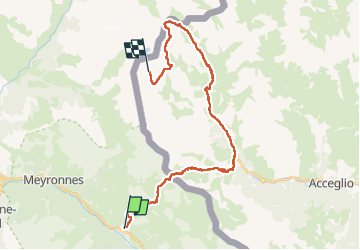
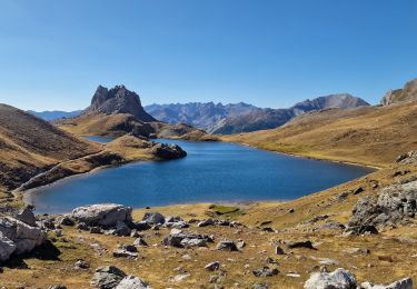
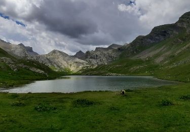
Trail Walking of 28 km to be discovered at Provence-Alpes-Côte d'Azur, Alpes-de-Haute-Provence, Val-d'Oronaye. This trail is proposed by tchoua.

Description

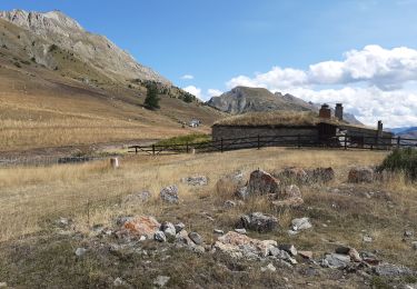
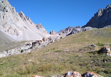
Après le col marinet  garder du jus la montée et la descente du col de ciaslaras sont exigeantes pour les jambes pente raide éboulis puis on remet ça après un long plat pour le colle del infernetto idem plus technique passages sécurisés (câbles) après ça il y a 2h  pour arriver au bivouac Barenghi  beaucoup de lacs entre pour s arrêter à savoir une chose le bivouac barenghi est très très petit 8 places de   vous n êtes qu à 1h 30 du refuge du chambeyron .Très important prendre en compte la météo italienne vous êtes dans le Piémont italien et cela n a rien avoir avec les prévisions météo france. Notamment en ce qui concerne la brume et les orages pour ceux qui se sont fait coincés par la nebbia qui remonte du PO s en souviennent.

Elevation profile

Photos

Positioning

Country:
France
Region :
Provence-Alpes-Côte d'Azur
Department/Province :
Alpes-de-Haute-Provence
Municipality :
Val-d'Oronaye
Location:
Larche
Start:(UTM)
328823 ; 4924382 (32T) N.

Trails nearby

Trail Walking Val-d'Oronaye - Saint Ours - Plateau de Mallemort - Photo
Walking
Coqorico

Walking

Very easy
(2)
Val-d'Oronaye, Provence-Alpes-Côte d'Azur, Alpes-de-Haute-Provence, France
10.4 km | 15.4 km-effort
1h 49min
Yes
Trail Walking Val-d'Oronaye - Fort de Rochecroix PR43 - Photo
Walking
ged94

Walking

Medium
(1)
Val-d'Oronaye, Provence-Alpes-Côte d'Azur, Alpes-de-Haute-Provence, France
10.1 km | 18.2 km-effort
6h 13min
No
Trail Walking Val-d'Oronaye - Rando Tête de SAUTRON-Tête de VIRAYSSE - Photo
Walking
trailer.nono

Walking

Medium
(1)
Val-d'Oronaye, Provence-Alpes-Côte d'Azur, Alpes-de-Haute-Provence, France
20 km | 45 km-effort
6h 0min
Yes
Trail Walking Val-d'Oronaye - LARCHE lac de la Orenaille  .Tour du lac de Roburent  o  - Photo
Walking
RobinMicheline

Walking

Difficult
(2)
Val-d'Oronaye, Provence-Alpes-Côte d'Azur, Alpes-de-Haute-Provence, France
14.2 km | 24 km-effort
6h 47min
Yes
Trail Walking Val-d'Oronaye - fort roche la croix - Photo
Walking
rvmp

Walking

Easy
(1)
Val-d'Oronaye, Provence-Alpes-Côte d'Azur, Alpes-de-Haute-Provence, France
13.6 km | 23 km-effort
7h 11min
Yes
Trail Walking Val-d'Oronaye - Batterie de Viraysse - Photo
Walking
GUIDE
R@ph

Walking

Difficult
(1)
Val-d'Oronaye, Provence-Alpes-Côte d'Azur, Alpes-de-Haute-Provence, France
17.4 km | 36 km-effort
6h 0min
Yes
Trail Walking Val-d'Oronaye - Mont Scaletta (col de Larche) - Photo
Walking
PapouBertrand

Walking

Very difficult
Val-d'Oronaye, Provence-Alpes-Côte d'Azur, Alpes-de-Haute-Provence, France
19 km | 34 km-effort
7h 39min
Yes
Trail Walking Val-d'Oronaye - Lac du Lauzanier - Photo
Walking
GuyVachet

Walking

Difficult
Val-d'Oronaye, Provence-Alpes-Côte d'Azur, Alpes-de-Haute-Provence, France
14 km | 21 km-effort
4h 53min
Yes
Trail Walking Val-d'Oronaye - FORT DE ST-OURS HAUT - Photo
Walking
walrou63

Walking

Easy
Val-d'Oronaye, Provence-Alpes-Côte d'Azur, Alpes-de-Haute-Provence, France
3.7 km | 5.2 km-effort
3h 15min
Yes


Close
My subscriptions