Trail On foot Loutehel - La vallée de ropenard - Photo

La vallée de ropenard

 jackpot
jackpot

User

© OpenStreetMap contributors
Length
Length
11.9 km
Max alt
Max alt
113 m
Uphill gradient
Uphill gradient
174 m
Km-Effort
Km-Effort  
14.2 km
Min alt
Min alt
49 m
Downhill gradient
Downhill gradient
174 m
Boucle
Boucle
Yes
Creation date :
2022-07-26 16:59:18.1
Updated on :
2022-08-07 09:34:51.414

(0 Reviews)

On foot
On foot
3h13
Difficulty : Easy

Scan this QR Code to open this trail in the SityTrail application

FREE GPS app for hiking

Logo SityTrail SityTrail

IGN / Geographical institutes

Download SityTrail from the App Store Download SityTrail from Google Play

Logo SityTrail SityTrail World

The world is yours!

Download SityTrail from the App Store Download SityTrail from Google Play Download SityTrail on Huawei AppGallery

About

Trail On foot of 11.9 km to be discovered at Brittany, Ille-et-Vilaine, Loutehel. This trail is proposed by jackpot.

Description

Randonnée à l'ombre dans les bois en grande partie, agréable sur des chemins de terre.

Elevation profile

Positioning

Country:
France
Region :
Brittany
Department/Province :
Ille-et-Vilaine
Municipality :
Loutehel
Location:
Unknown
Start:(UTM)
568665 ; 5309481 (30T) N.

Trails nearby

Trail On foot Maxent - Circuit de L'Emeheuc - Photo
On foot
PRO

On foot

Easy
Maxent, Brittany, Ille-et-Vilaine, France
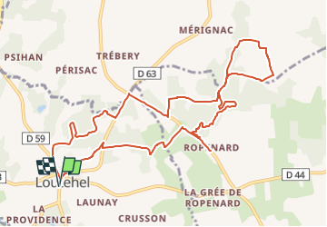
7.2 km | 8.5 km-effort
1h 55min
Yes
Trail Walking Saint-Malo-de-Beignon - 16.05.2019 - ST Malo de BEIGNON à GUER - Photo
Walking
babeth35

Walking

Difficult
Saint-Malo-de-Beignon, Brittany, Morbihan, France
31 km | 37 km-effort
7h 37min
Yes
Trail Walking Guer - essai - Photo
Walking
altijovima

Walking

Medium
Guer, Brittany, Morbihan, France
8.6 km | 10.4 km-effort
Unknown
No
Trail Walking Val d'Anast - campeljuin - Photo
Walking
ballay

Walking

Very easy
Val d'Anast, Brittany, Ille-et-Vilaine, France
12.2 km | 14.4 km-effort
2h 46min
No
Trail Walking Loutehel - Le louetel - Photo
Walking
Ameligue

Walking

Very easy
Loutehel, Brittany, Ille-et-Vilaine, France
9.3 km | 10.8 km-effort
2h 32min
Yes
Trail Walking Guer - Boucle du Dran - Guer - Photo
Walking
tracegps

Walking

Medium
Guer, Brittany, Morbihan, France
11.2 km | 13.4 km-effort
3h 0min
Yes
Trail Walking Plélan-le-Grand - Le fief du thé lin - Photo
Walking
elieb

Walking

Difficult
Plélan-le-Grand, Brittany, Ille-et-Vilaine, France
11.7 km | 14.5 km-effort
3h 15min
Yes
Trail On foot Plélan-le-Grand - le Fief du Thélin - Photo
On foot
elieb

On foot

Easy
Plélan-le-Grand, Brittany, Ille-et-Vilaine, France
11.2 km | 13.9 km-effort
3h 9min
No
Trail Walking Guer - 19.10.2020 - MONTENEUF - Photo
Walking
babeth35

Walking

Medium
Guer, Brittany, Morbihan, France
31 km | 36 km-effort
7h 25min
Yes


Close
My subscriptions