


Boucle noire Charleroi

michelcortvrint
User
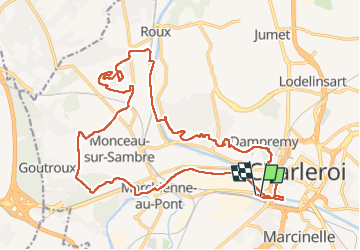

Length
22 km

Max alt
199 m

Uphill gradient
361 m
Km-Effort
27 km

Min alt
96 m

Downhill gradient
359 m
Boucle
Yes
Creation date :
2022-07-27 05:54:44.0
Updated on :
2022-07-27 10:03:39.149
3h16
Difficulty : Difficult

FREE GPS app for hiking
 SityTrail
IGN / Geographical institutes
SityTrail Plus
The world is yours!
About
Trail Trail of 22 km to be discovered at Wallonia, Hainaut, Charleroi. This trail is proposed by michelcortvrint.
Positioning
Country:
Belgium
Region :
Wallonia
Department/Province :
Hainaut
Municipality :
Charleroi
Location:
Unknown
Start:(Dec)
Start:(UTM)
601681 ; 5584794 (31U) N.
Comments