


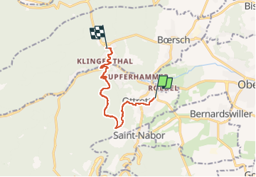
Ottrott tour de France femmes
© OpenStreetMap contributors


3h01
Difficulty : Difficult


Length
7.9 km
Max alt
523 m
Uphill gradient
343 m
Km-Effort
12.2 km
Min alt
261 m
Downhill gradient
260 m
Boucle
No
Creation date :
2022-07-29 08:31:23.323
Updated on :
2022-07-29 11:33:57.269
3h01
Difficulty : Difficult
FREE GPS app for hiking
 SityTrail
IGN / Geographical institutes
SityTrail Plus
The world is yours!
About
Trail Walking of 7.9 km to be discovered at Grand Est, Bas-Rhin, Ottrott. This trail is proposed by Dominique Baudelocque .
Description
Klingenthal
Positioning
Country:
France
Region :
Grand Est
Department/Province :
Bas-Rhin
Municipality :
Ottrott
Location:
Unknown
Start:(Dec)
Start:(UTM)
384096 ; 5368382 (32U) N.
Comments