


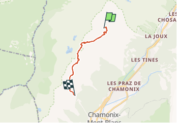
col de l'index / Planpraz

GeRv
User

Length
6.2 km

Max alt
2494 m

Uphill gradient
283 m
Km-Effort
11.2 km

Min alt
2007 m

Downhill gradient
667 m
Boucle
No
Creation date :
2022-07-29 14:59:16.221
Updated on :
2022-07-29 15:00:08.032
2h32
Difficulty : Easy

FREE GPS app for hiking
 SityTrail
IGN / Geographical institutes
SityTrail Plus
The world is yours!
About
Trail On foot of 6.2 km to be discovered at Auvergne-Rhône-Alpes, Upper Savoy, Chamonix-Mont-Blanc. This trail is proposed by GeRv.
Positioning
Country:
France
Region :
Auvergne-Rhône-Alpes
Department/Province :
Upper Savoy
Municipality :
Chamonix-Mont-Blanc
Location:
Unknown
Start:(Dec)
Start:(UTM)
335194 ; 5092742 (32T) N.
Comments